Sun and wildfire smoke mixed in the New England sky again Thursday morning, but by late day our First Alert team expects clouds to increase and take over. All the while, a southwest wind continues to transport mild air into central and southern New England with high temperatures nearing 80 degrees Thursday afternoon.
An incoming cold front will prompt sprinkles and light showers in northern New England just ahead of a change in the wind direction. The new, northerly wind opens a flow of cooler and drier air from Canada into New England. Skies will gradually clear in northern New England overnight Thursday, but there's a chance for some Friday morning showers in southern New Hampshire and below.
Download our free mobile app for iOS or Android to get the latest breaking news and in-depth coverage of COVID-19.
The cold front will encounter a bit of enhanced moisture with the decaying remnant of once-Hurricane Sally, so Cape Cod may see some rain through Friday midday before drying takes over for one and all. The sky clears heading into Friday night, with the northern half of New England susceptible to frost.
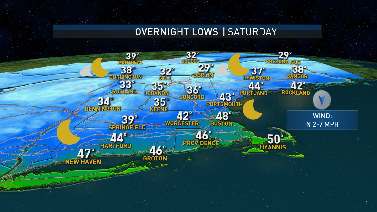
We will have abundant sunshine but cool temperatures on both weekend days with highs near 60 degrees. Overnight lows could be cold enough for frost as far south as central and western Massachusetts as well as northern Connecticut!
Tide levels will be high due to the new moon this weekend. Minor coastal flooding is quite possible in typically vulnerable areas during high tide, particularly at midnight Thursday and Friday nights as well as midday Saturday.
Next week starts dry and likely stays that way, but we’ll be watching an interaction between storms in the northern Atlantic carefully.
Major Hurricane Teddy should move into the north Atlantic after passing near or over Bermuda, which was recently hit by Hurricane Paulette. There, Teddy will absorb the weakened remnant of once-Hurricane Sally into its much larger and stronger circulation. The situation is further complicated by the jet stream winds aloft dipping south from Nova Scotia through Atlantic Canada.
If this colder air and energy merges with the combined tropical systems, we could have a powerful storm in the north Atlantic capable of throwing some big waves toward New England’s coasts. If it develops far enough west, it could perhaps even bring some rain bands Tuesday or Wednesday.
That said, you won’t see that rain on our exclusive First Alert 10-day forecast. That scenario isn’t very likely, but it’s a possibility we’ll continue to watch, just in case. We'll keep you posted on in our forecasts.
"come" - Google News
September 17, 2020 at 11:00PM
https://ift.tt/2ZOe5q9
From 80 Degrees to Frost, Dramatic Change to Come - NBC10 Boston
"come" - Google News
https://ift.tt/2S8UtrZ
Shoes Man Tutorial
Pos News Update
Meme Update
Korean Entertainment News
Japan News Update
Bagikan Berita Ini


0 Response to "From 80 Degrees to Frost, Dramatic Change to Come - NBC10 Boston"
Post a Comment