A cold front brought rain showers that transitioned to light snow earlier today, but all of that has pushed to the east. Colder temperatures will continue to filter in through the evening into the weekend.
Overall our forecast is looking well below average through next week.
A SEASONAL FRIDAY
First of all, Friday morning will have a chance for passing flurries north of I-70. Meteorologist Tim Schmidt will be tracking that in the morning.
Morning wind chills will be in the 10s.
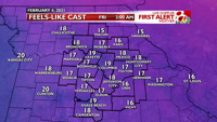
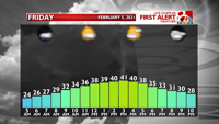
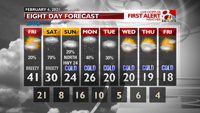
Before we head into the cold deluge of next week we'll have a seasonal day on Friday with highs in the lower 40s and lows in the middle 20s.
We’ll see a mix of sunshine and cloud cover through the afternoon. A quick wave of energy will have the potential to bring a few flurries Friday afternoon and evening, but these will not accumulate or cause any issues.
THE NEXT SNOWFALL
Snow will move into the region once again on Saturday. It will start in the mid to late morning and should exit by early evening. Therefore, expect a snow Saturday afternoon throughout central Missouri. Highs will be near 30º, so this should be a fluffier/wetter snow.
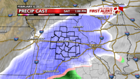
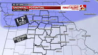
This snow will lead to minor accumulations. Areas along and south of I-70 will be on the lower end of the totals, picking up a dusting to an inch of snow. Locations north of I-70 will see slightly higher totals thanks to increased lift in the atmosphere creating more snowfall, with 1-2” of snow and up to 3” locally. Ground temperatures will have the opportunity to cool over the next several nights, so it is likely that this snow will start sticking as soon as it begins.
THE COLDEST PATTERN OF WINTER
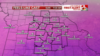
Sunday morning will start with low temps in the single digits. Morning wind chills will range from 0 to -10°. Highs will climb to the middle 20s in the afternoon with mostly cloudy skies. We’ll need to watch a passing wave to the north of HWY 24 that could bring light snow to northern Missouri.
Another push of moisture will bring another chance of snow Monday and Tuesday. It is too early to talk specifics with accumulation, but they do look low at this point. This is still several days away so the track of the moisture could shift. Stay tuned!
A cold pattern is likely to persist through next week with highs in the 10s and 20s and lows in the single digits. We will also need to watch for additional waves of energy that could bring light snow chances. Overall, the middle and end of next week is looking drier.
"come" - Google News
February 05, 2021 at 08:30AM
https://ift.tt/39PWTWI
Forecast: The coldest part of winter is still to come - KOMU 8
"come" - Google News
https://ift.tt/2S8UtrZ
Shoes Man Tutorial
Pos News Update
Meme Update
Korean Entertainment News
Japan News Update
Bagikan Berita Ini


0 Response to "Forecast: The coldest part of winter is still to come - KOMU 8"
Post a Comment